AI System to Map Deep-sea Seamounts
An Intelligent Seamount Digital Twin System was recently launched during a side event of the United Nations Ocean Conference (UNOC) held in France.
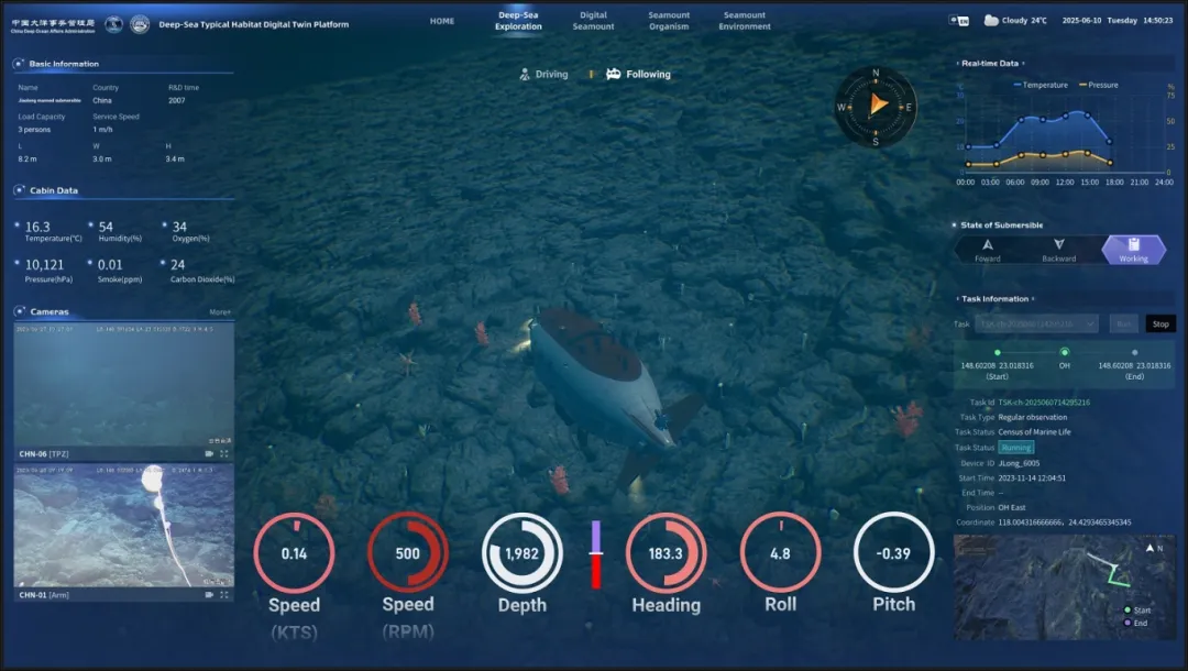
The system, jointly developed by China Deep Ocean Affairs Administration (CDOAA) and institutions including Zhejiang Lab, integrates AI tools and high-resolution multi-source data to enable 3D mapping of deep-sea habitats and digital twin system of seamounts.
Themed "Approaching an intelligent and inspiring ocean: new science-based actions for sustainable futures," the UNOC event sought to promote the open sharing of global ocean data, enhance ocean early warning and service capabilities, advance deep-sea digital simulation, and foster the innovation and application of marine science and technology.
It marks China's first publicly available digital sci-tech product in the field of deep-sea exploration. As the global oceans face unprecedented challenges, including climate change, biodiversity loss, and escalating pollution, the system will fill the gap in application of AI technology in deep-sea exploration, marking a shift toward a new era of digital and intelligent deep-sea development.
This system also demonstrates China's concrete actions in contributing to the vision of the UN's "Ocean Decade" and its active role in participating in global ocean governance.
In 2023, the Digital Deep-sea Typical Habitats Programme (Digital DEPTH), initiated by the CDOAA under the framework of the UN's "Ocean Decade," was launched.
It focuses on deep-sea habitats including seamounts, mid-ocean ridges, abyssal plains and continental slopes, and improves human observation, simulation, and mapping capabilities of these typical habitats of the deep-sea, thus helping humankind to find the best solutions to achieve a balance between deep-sea conservation and sustainable development.